


Our news
Closing seminar
10h15 : Echanges et Présentations des travaux réalisés en France sur la désimperméabilisation des sols
- Catherine LEONARD (CEREMA)
- Cécile LE GUERN (BRGM)
- Marjorie MUSY (CEREMA)
- Thomas LEDUC (CRENAU)
- Clément BRUHAT (OTEIS)
- Bhuvanesh CLEMENCEAU
12h30 : Pause
14h00 : Echanges et Présentations des travaux réalisés en Chine sur la renaturation urbaine
- Pr. Li QIONG (SCUT)
- Pr. Juanyu WU (SCUT)
- Shuqi LIU
15h30 : Clôture par le Pr. Emmanuel DUFRASNES

Our selection of places in Guangzhou ?
IBased on the previous mapping production, we made a selection of sites in Strasbourg and Guangzhou, chose 2 or 3 locations that meet the requirements and will propose some targeted recommendations of desealing for them.
Firstly, according to a series of mapping results about the urban heat island effect, hydrogeology, distribution of soil infiltration coefficient and zoning maps of various natural hazard, with the aim of selecting sites with notable heat island effect, good infiltration coefficients, non-dense distribution of groundwater network and avoiding geological disasters as much as possible, while considering other factors such as: traffic, building density, distribution of impervious surfaces, etc.
Taking all these into consideration, we selected the following sites in Guangzhou.
(1) Jiahui Plaza, located on the border between Guangzhou and Foshan, is far from the city center, surrounded by residential areas and George Chinese&English School, which mainly provides dining and entertainment functions for habitants in residential areas. Here has a significant heat island effect and low soil infiltration capacity (Coefficient less than 0.1). Part of the parking lot is grassed, but the rest is more of an impervious concrete surface. In addition, it also exists some impervious paving surfaces around the shopping center.
(2) The industrial commercial district of technology design, where a number of technology enterprises are located (for example, Xie Sheng Building, Dongxinda Computer Technology Development Co., Ltd., Science and Trade Centre and other technology enterprises) also has residential spaces around this area. It has a strong heat island effect compared to the surrounding area, with an infiltration coefficient from 0.1 to 0.2. Here is mainly used as an office block, with many vehicles parked along the road. There’s some green space, but it is mostly roadside trees. And the density of vegetation in the small garden is sparse and not so ideal .
3) We chose Mahui Jiajucheng in Tianhe District, near the city center. Despite it’s closed to Pearl River Park, the heat island effect is still intense there. Many sports facilities sit here, such as tennis courts, basketball courts and golf courses. In addition, we can also find many car sales or repair centers along the street, so there is a large amount of concrete and cement impervious surfaces for vehicle parking.
In short, after careful consideration, these three places have been selected for desealing, and then we will summarize various measures and provide targeted advice for these locations.
Realising the catalog of solutions
Within the framework of identifying the potential desealing areas in confines of study (CoMix research project about soil desealing in France and China): the City and Eurometropolis of Strasbourg (la Ville et l’Eurométropole de Strasbourg / EMS), and Guangzhou, China, it’s necessary to draw up a catalog of solutions on soil desealing and revegetation.
In order to produce this catalog, we consulted several documents about desealing and revegetation, which come from different sources (NAIAD, European Commission, Think Nature, Plante&Cité, The Nature Conservancy or UNaLaB). We selected the content provided by UNaLab as a support, which is so detailed and gives an overview of procedures to follow for every different solutions. While it’s more relevant to the Eurometropole of Strasbourg, because the solutions proposed in this document are more applicable to European environmental criteria and standards, but maybe some solutions can be implemented in China.
Talking about Guangzhou, several sources were analyzed (Shenzhen Housing and Construction Bureau, Xiong'an Vank Development Center of Green Research, UNaLaB, etc). The solutions were extracted according to these information gathered from the different sources.
The selected solutions correspond to developments that can be carried out on the ground, roofs and walls, such as the ditches, vegetated pavement, permeable stone carpet, green roof or a green mobile space. Firstly, making a description of the solution, the main actions, the technical and design parameters, the advantages and the limits, adding or subtracting appropriately some other criteria for these solutions. In addition, we need to have a certain understanding related to daily maintenance, the manpower, the cost, the material, the operation and the frequency. The proposals made for the last criterion are relative, they depend on the environment in which the development will be made.
Later we need to present this catalog of solutions to the various actors participating in the project (Eurometropole of Strasbourg, South China University of Technology, CEREMA...) in order to verify their implementation.
Applying the Results of Methodology provided by CEREMA in Eurometropolis of Strasbourg
Within the framework of identifying the potential desealing areas in confines of study (CoMix research project about soil desealing in France and China): the City and Eurometropolis of Strasbourg (la Ville et l’Eurométropole de Strasbourg / EMS), and Guangzhou, China, the objective is to reproduce the methodology of soil desealing provided by CEREMA, which was ever used in Grand Narbonne, and this target is almost completely achieved now.
According to this methodology, territory of EMS is analyzed by three axes:
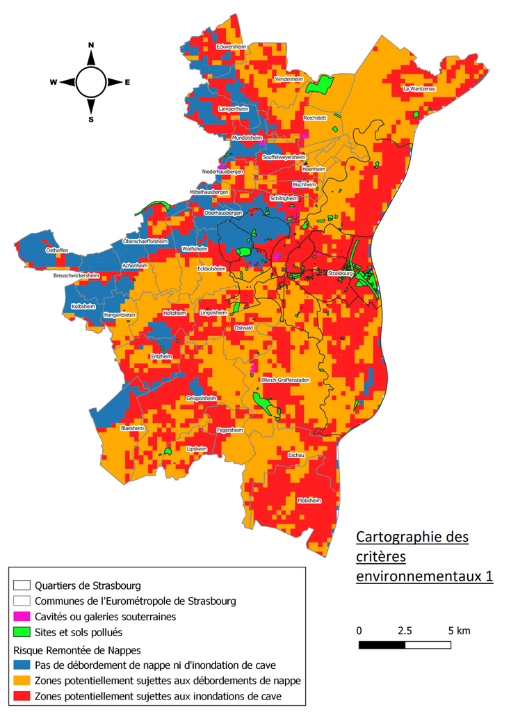
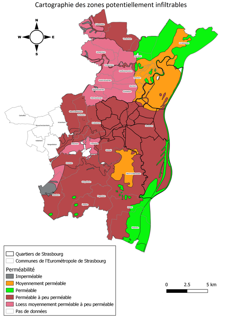
1) Potentially Infiltrable Zones (ZPI), in which the objective was to observe the superposition of geological layers and their permeabilities, in order to observe the potential of infiltration in the soils.
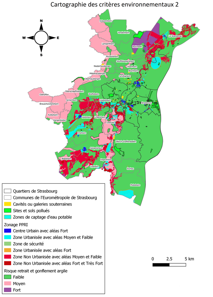
2)Environmental Criteria Zones (ZCE), in which the objective was to observe the spatial distribution of several criteria: drinking water catchments, polluted sites and soils, underground cavities, piezometers (to analyze groundwater levels), risks about shrinkage and swelling of clay, risks about rising of the water tables, topography and flood zones so that we can obtain their distribution on the study territory.
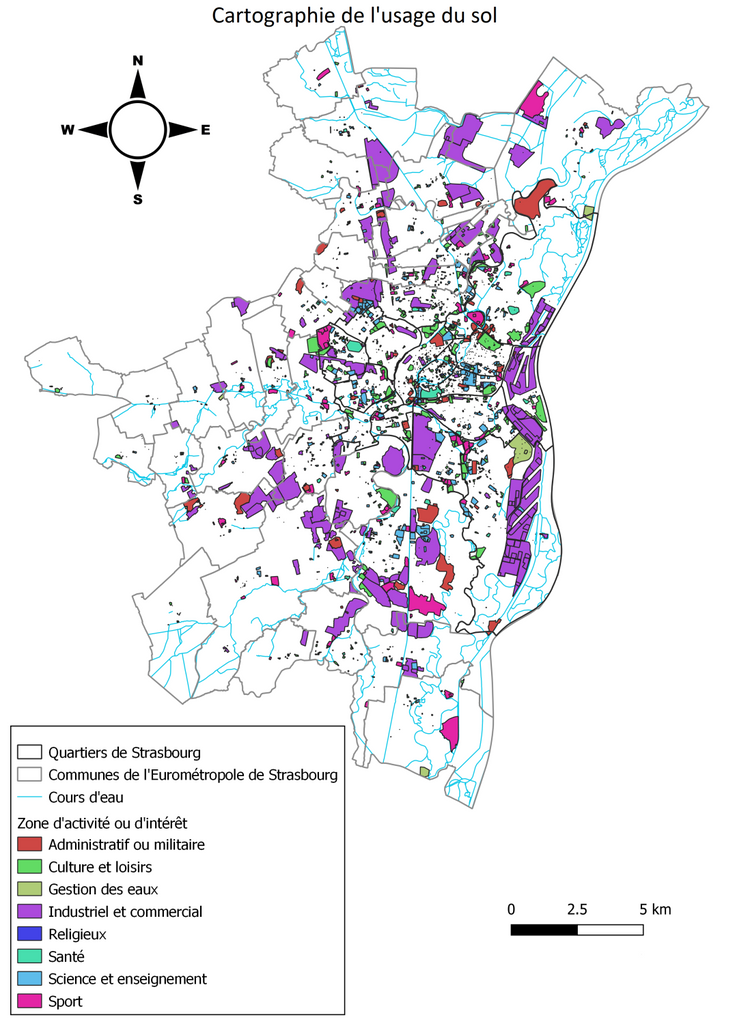
3)Land use, getting the distribution of the elements within the study area by analyzing the location of impervious surfaces, activity area, water and vegetation.
When we apply this methodology to EMS, the main difficulty was to find the precise pedological data. In fact, in the original conception of the method, only one measurement point was available for analysing the superposition of geological layers and its permeability, based on the data provided by the soil quality monitoring network (le Réseau de mesures de la qualité des sol - RMQS). Later, we used the data from the BRGM (“Cartographie de la peréabilité des formations superficielles du territoire de la Communauté Urbaine de Strasbourg”), which are much more precise and obtained from several measurement points, it’s more possible to get the better results. The only limitation of this report is it only concerns the Urban Community of Strasbourg, but not the Eurometropolis of Strasbourg, it means the other five municipalities in EMS have not been taken into account.
Later, firstly, we would identify some small-scale zones (streets, buildings, parking lot, etc.) Secondly, drawing up a catalog of desealing solutions in order to develop our desealing project more concretely.
Our methodology test of "Grand Narbonne" to Strasbourg ?
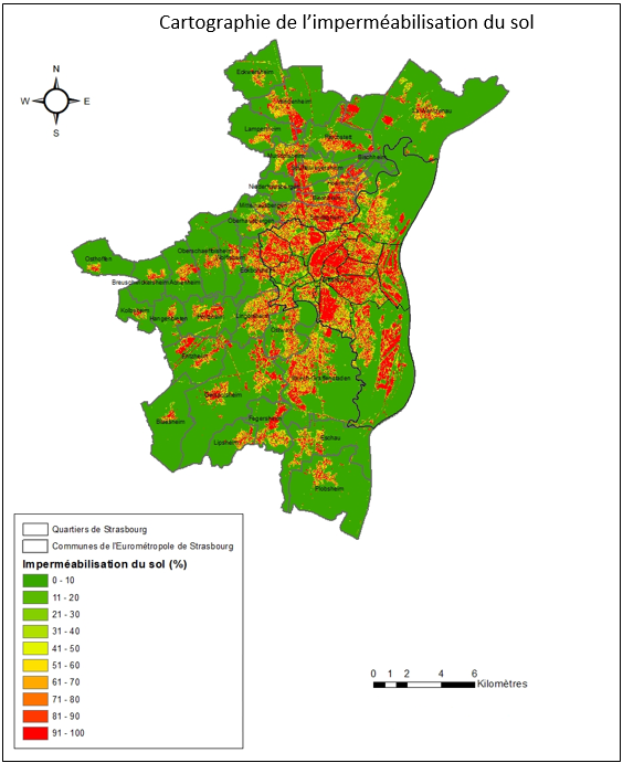
Within the framework of the objective for identifying the potential desealing areas in the City and Eurometropolis of Strasbourg (CoMix research project of desealing of soils in France and China), the methodology of desealing in Grand Narbonne is reapplied on the territory of the City and Eurometropolis of Strasbourg.
In this methodology of the Grand Narbonne, three types of maps are carried out in order to determine the potential zones to be desealing: infiltration map, the environmental criteria and the land use. Concerning the infiltration map(soil and subsoil permeability), it is more precisely a question of using the "BDLISA" or "Indice de Développement et de Persistance des Réseaux" (BRGM) layers, to observe in particular the hydrology and geology of a given area. For the environmental criteria, it includes such as the quarries and polluted sites, the risks of rising water table, the areas of catchment of drinking water or the underground cavities which are observed, for identifying the criteria which could limit the infiltration of water. Finally, concerning the land use, by using data related to the levels of occupation, the distribution of elements in space or the urban planning documents, the objective is to observe the current situation of land use on a space.
The map of the environmental criteria for the City and Eurometropolis of Strasbourg is almost completed. And the map of infiltration, as it requires the precise information about the nature of the soil and subsoil, the processing is longer. Finally, the last map concerning the occupation of the soil has not yet started.
Some difficulties are still to be noted here, for example, there is no shapefile data about the topography for the territory of the City and Eurometropolis of Strasbourg, it is also very difficult to obtain data on the depth of the layers in the soil, especially for the city of Strasbourg and finally it is difficult to reproduce the methodology of the Grand Narbonne on the City and Eurometropolis of Strasbourg because the territories are different (location, area, population, material content ... ) this produces insignificant cartographies, especially if the same criteria as the Grand Narbonne are chosen.
Our data research in Guangzhou ?
In the process of promoting the CoMix 2021-2022 Sino-French cooperation project, we chose Guangzhou as an study object in the Chinese part, collected and collated data for it.
In order to achieve the goal of desealing in Guangzhou, we need various data related to land-use, buildings, green areas, water system, topography, temperature, population, types of soils, etc. to complete the mapping on diverse aspects such as infiltration, distribution of impervious surface, heat island effect, flooding, and so on.
However, we also confront many defects of Chinese data during the collection process.
- Firstly, poor in open source. Different with the data sources of French cities, such as OpenDataStrasbourg.eu for Strasbourg or data.nantesmetropole.fr for Nantes, Chinese administrative websites or academic institutions are more likely to publish the conclusive content directly, but rarely post the relative raster or vector data they have used for study. Especially those who are regarded as "confidential" such as building data, it’s even more difficult to obtain.
- The originality of the data. Unlike the European where most of the data are fully processed and ready to be used directly. Many Chinese researches are based on the original remote sensing images, for instance, Landsat and MODIS, which require a series of pre-processing manipulation, e.g. radiometric correction, geometric correction and conversion to vector data before use, which is a thorny and time-consuming process.
- Too large. Many data in China are collected by country, region, or province, which means we have to face an excessive data if we would be with the premise of requiring accuracy. Besides, usually, we need to filter the study area from many information by extraction before proceeding with the mapping work.
- Lack of information and confusion. We have tried to get the vector data about buildings in Guangzhou from many ways, but some of them only include the central city, or the attribute table lacks the information such as the height and type of structure, which brings a lot of troubles for the subsequent cartography work.
The above problems have brought difficulties for us to carry out the cartography of desealing project. Considering of this, we have actively sought the help of laboratories in various Chinese universities, for example, South China University of Technology (SCUT), Wuhan University (WHU)and Nanjing Normal University (NNU), in order to obtain the data as soon as possible and advance to the next step of the cartography.
Wich datas used for Guangzhou ?
In order to realize the task of the CoMix 2021-2022 Sino-French cooperation project and to evaluate the potential of desealing, Guangzhou was selected as the research object in Chinese part of our study.
Guangzhou, one of the most important economic centers in China, is located in the coastal zone of the subtropical monsoon climate area, with the Pearl River running through the whole city. And Guangzhou is with abundant rainfall and hot, suffers frequent typhoons, especially in summer, that means it would be more significant to implement the research about desealing here.
We obtain relevant data through some official websites, such as https://data.tpdc.ac.cn/zh-hans/, https://www.resdc.cn/Default.aspx, http://39.106.90.21/, https://www.scidb.cn/, etc. and also from some public institutions, for example https://www.beijingcitylab.com/, http://data.ess.tsinghua.edu.cn/, etc. Then we sorted this data into different types: land-use, buildings, Hydrology, impervious surfaces, etc.
As the data in China are mostly studied for the whole country, some regions or a province, usually data will cover a large areas. Also it's poorly open-sourced, with a wide variety of data types, which even involve problems such as missing information or confusing projections, that means a series of checking and pre-processing are required before implementing mapping operations.
In addition, Chinese data are more from the remote sensing, such as extracting vegetation cover data from NDVI and obtaining temperature changes in Guangzhou from MODIS to study the impact of impervious surfaces on the urban heat island effect.
Considering these issues, we are actively seeking help from our Chinese partners in order to better achieve the goal of desealing research in France and China.
Wich datas used for Strasbourg ?
Within the framework of the CoMix research project on soil desealing in France and China, it’s necessary to collect available data for setting up an inventory of existing data and even sometimes we need to create some new data, and it will make us to meet the objective of identifying the potential desealing areas in the territories of City and Eurometropolis of Strasbourg, as well as in China.
In order to realise it, a large amount of data was found in official websites such as OpenDataStrasbourg.eu, data.gouv.fr, DataGrandEst.fr or insee.fr. And some other comes from the organisation related or unrelated with the government, such as cerema.fr, meteofrance.com, ign.fr or brgm.fr.
By visiting these different sources, several file formats were available, for example CSV, JSON, Excel, GeoJSON, Shapefile or KML. For using these data directly in ArcGIS, Shapefile format will be considered in priority, because its data composition (points, lines, polygons) can be operated easily in ArcGIS.
Besides, a sorting of these data will be important, so we will establish different categories mainly corresponding to the types of land-use: transportation network, building, hydrographic net, vegetation, zone of economic activity, flooding zone... Thereafter, various combinations of these categories will be used to identify the potential desealing zones.
In particular, the aerial photographs who are mainly from Google Maps, Google Earth, Remonterletemps.ign or the other sources, will be used to observe the green roofs.
Finally, It is possible to create data about the ability of infiltration and impermeability which can provide some precise details about the soil structure.
Wich GIS tool ?
As a part of a #CoMix research project on soil desealing in France and China, one of our objectives is to identify the potential areas for desealing in Strasbourg, as well as in China.
In order to meet this objective, it is necessary to use a Geographic Information System tool (#GIS) for realising the production of cartography and the data processing.
After comparing different GIS software, two of them could meet our expectations, #QGiS and #ArcGIS. By comparing these two, we prefer to choosing ArcGIS. On the one hand, it performs better when processing large amounts of data. On the other hand, it is compatible with a greater number of programming languages. Besides, #ArcMap Online included in the ArcGIS suite can provide official data and detailed base maps. In addition, our Chinese partners from 华南理工大学 (South China University of Technology) will also use it. Although QGIS is an open source software, it may need various plugins to expand its functionality, and it will be more complex and time consuming to convert different types of data (e.g. vector data, raster data) or even to achieve compatibility with data exported from other software.
In a word, in order to achieve the cartography for the potential desealing areas in Strasbourg, considering its complicated manipulation and an enormous amount of data, we will use ArcGIS as our principal tool.
Posts written about our project will also be accessible from the eegle platform.